


Return to the Peel Journal - Day 1
- Jul 17, 2018
- 4 min read
Day 1. Tuesday, July 17. Cool and overcast.
Our first day was the northern version of “Planes, Trains and Automobiles.”
In our case: Van, Float plane, Portage and Canoe.
We were up at 3 am for a five-hour van ride pulling a trailer with our Tsunami kayak, a 17 ft Prospector canoe and gear. The gear included two 60 liter barrels of food and two large dry bags carrying tents, clothes, sleeping bags and utility bag with all various other utensils and items we’d need and could fit in a 17-foot canoe.
Nothing but the essentials as there are strict weight restrictions for our float-plane trip into the mountains.

David, Graham and Terry getting ready to board their Beaver floatplane at Mayo, YT.
The flight from Mayo on the Beaver aircraft was lovely , over lakes, forest and muskeg and then directly between jagged MacKenzie mountain peaks that make up the top end of Rockies.
We landed on a tiny lake called McCluskey, in a mountain valley. A group of Germans was camped there (not unusual in the Yukon. Germans love it here. There are direct flights to Whitehorse in the summer). They reported sightings of moose. They also pointed to the dark clouds above and said they were staying put for a couple of days to wait for the weather to clear.

Flying into the McKenzie Mountains.
Not us! We’re on a mission! So with rain spitting down on us and temperatures around 12 degrees Celsius, we portaged our gear down the 300 yards to the stream that will carry us to the Wind River.
A good bit of northern travel advice is to heed the warnings of those who went before you.
Our guidebook (the excellent “Wild Rivers of the Yukon’s Peel Watershed,” by the late Juri Peepre and Sarah Locke) recommended lining the stream to the Wind. “More than one party has flipped canoes in this innocuous little stream.” It’s a pretty clear warning. But lining here involves trailing alongside your canoe in glacial cold water while scrambling over rocks and up and down muddy river banks. It’s a foot numbing experience, so we looked at water levels, which seemed reasonably high, and decided that we could manage to paddle. To be more transparent, Graham and I thought it would be fine, Terry, was less certain, so off we went paddling down the fast, narrow stream. Smooth sailing at first, but about 500 yards downstream, Graham, paddling solo ahead of us in the kayak, got hung up sideways between two rocks. With no room to get around him in the narrow stream, we bumped right into him, swung sideways and over we went.
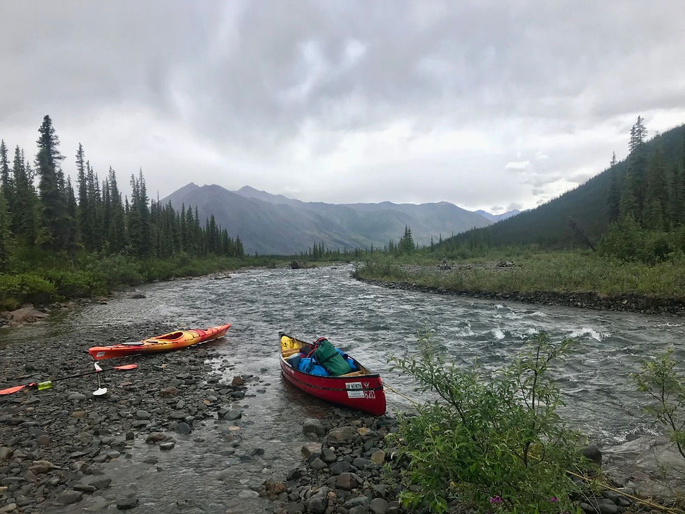
The start of our journey. We dumped just around that bend.
It’s a very sad feeling watching as your canoe fills up with water.
We hopped out, pulled it to shore, bailed it out and then, eating some crow, lined the canoe for a numbing two hours to the Wind, which, happily, was navigable. We got back into our canoe and paddled for two hours more.
The scenery on the Wind is stunning. My first impression as we start out was: “This is where the world began.” It is pristine, pre-industrial, a narrow mountain valley, forested with spruce.
The water is clear and “dip our cup in it to drink” clean. The only sounds you hear are natural: Birds and rushing water, wind through trees and more rushing water. No engines. No hum of traffic, not even planes passing by miles overhead. Just nature.
We set up camp just north of Nash Creek, where the Camsell expedition came into the Wind in 1905.
Here is his description of that moment, from his 1906 “Report on the Peel River and its tributaries.”

Near the headwaters of the Wind River.
“The valley occupied by the Wind river is broad and U-shaped, tlmbered in some parts by spruce and poplar, but totally bare in others. In this the Wind river flow in a broad, shallow bed sometimes half a mile wide. Where confined to one channel, the breadth of the stream before it meets Nash creek is 100 feet and it’s water is beautifully clear and blue.”
For all our complaining about lining a glacial creek for a couple hours, Camsell and his crew hauled all their gear for days over a mountain pass to get here.
Here is Camsell’s account (from his memoir “Son of the North.” Ryerson Press. 1954) of the difficult last leg he and his team of five faced, to reach this spot, on July 6, 1905:
“Not only was Nash Creek swift and shallow but it was sometimes blocked by snowslides from the bordering mountains. Once we had to run our canoe through a snow tunnel, rather than portage over the slide.”

Graham washing up at our first campsite.
We set up camp on the gravel bank in the rain and then pouring rain. Despite that, Terry, a native of Hay River, NWT
and the son of a trapper and park ranger, managed to get a roaring fire going with damp driftwood and a strung up a tarp for shelter. That improved our mood.
Graham and I got tents pitched on the stony banks of the river. We then cooked some dinner, freeze dried lasagna, heated up with boiling water (actually pretty delicious). We were in sleeping bags and out cold by 8pm.
Woke up at 1am. Sun is still up. Was hard to gauge the time.

Comments